There were a couple of excursions that I had booked ahead of time before leaving on our trip. Both of these excursions were booked for today. The first was a tour of the Big Island with the
Blue Hawaiian Helicopter Tours. I have always wanted to see a real volcano, and I did not think that we would be able to visit it on foot, so viewing it from the air was the next best thing!
I decided to book the
Big Island Spectacular as it was the only trip we could take to visit the volcano without having to drive all the way to Hilo. I did not expect too much from the Kohala portion of the trip.
 |
| On board a helicopter on our way to
Kilauea. |
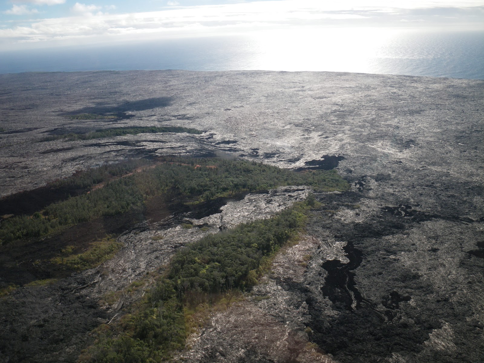
Viewing the lava flows from the air gives quite a perspective of how much area is affected by any eruptions from the active volcanos on the island. Land that use to have people and houses and resorts were completely wiped out, with some odd pockets of land being spared.
 |
| The lava flow of an eruption many years
ago. |
Maggie was immediately bothered by the
vog (volcanic fog) that permeated the air during our flight to the volcano. I did not notice it too much, but then again, I have a terrible sense of smell. When we few over the caldera of
Kilauea, the current very active volcano, I was quite disappointed to see that nothing was going on. There was steam coming out of the crater, but no active lava flows. I should take that back. There was indeed an active lava flow, and we did fly over it. The pilot pointed it out and upon closer inspection one could see the dull red glow from the hot lava. Unfortunately, in the midday sun, any glow was pretty much washed out and it looked like part of the rest of the black basalt that covered the lands.
 |
| A closer look of the house that was
spared by the lava. The guy is still living there! |
As we headed back north, taking the long way back to the heliport, we passed by Hilo and saw many macadamia farms in addition to rivers flowing down the mountain. When we reached the coast, we watched as it rose out of the ocean floor, becoming a sheer cliff with V shaped valleys cut through by small rivers that emptied into the ocean as waterfalls over the ledge. Even further north we flew into a deep gorge where the steep walls of the valley were littered with waterfalls. There were waterfalls everywhere! It was indeed a sight to behold.
 |
| One of the many waterfalls that we saw
while flying in the Kohala area of the Big Island. |
That area of the island is so remote that it was impossible to view it by land. The only way to see these sights is from the air. I would say that the view blew me away. I would certainly recommend that people see that part of the island.
 |
| The two of us standing in front of the
helicopter we just flew in. |
All in all, the helicopter portion of the day was okay. It was pretty expensive but worth the cost because you need to see it at least once in your life.
Afterward, we drove back to Kona for lunch at Bongo Ben's Island Café. The food was okay and the view was nice from the patio. We did not have too much time to relax before the next half of today's adventure.
 |
| Having lunch at Bongo Ben's Island
Café. |
The second half of the day was reserved for a trip up to watch the sunset on the summit of
Mauna Kea with
Mauna Kea Summit Adventures. We would get picked up in Kona and get driven in their bus to the summit of the mountain. They would also provide parkas to handle the freezing temperatures, as well as dinner.
It was hot though that afternoon. So Maggie and I got some ice cream while we waited for our pickup. Our driver was young, but knowledgeable enough about the stuff we were asking him. For example, Maggie and I noticed a lot of graffiti next to the road that was made from white rocks. Apparently these white rocks were made from coral, which was used to build the road that we were driving on. Extra rocks were left next to the road, and people over time have used those rocks to create messages for anyone driving down the highway.
 |
| Some graffiti made from the white coral
rocks that were left over when the road was built. |
On the way up, we passed through areas that we flew over earlier in the day. We passed by an old army base, and then stopped off at an old lava flow where we took a number of photos.
 |
| Maggie and one of the many old lava
flows on the island. |
We took a number of stops as we drove up the mountain. Part of the reason was to see the sights, but another reason was to acclimate to the lower oxygen levels at the higher elevations so that the tourists would not suffer from hypoxia at the summit.
 |
| Me trying to climb out of a steep spot
on the old lava flow. |
Our next stop after the lava flow was the
visitor information station where we were served our dinner and had time to relax and look around. Dinner was.. meh. But I did notice a few things while we were up there: The lights in the washroom were all red, and the lamps in the bus we were travelling in were also red. I'm assuming that it's because these lights would not interfere with the sensors on the telescopes at the top of the mountain.
In addition, the all street lights were using sodium lamps. I remember seeing them used on the Don Valley Parkway and the Gardener Expressway back in the day which is how I recognized them here. Sodium lamps emit at specific frequencies, and can be more easily removed from their observational noise than regular street lamps. We were told by the guide that light pollution is limited on the island so as not to interfere with the observations made by the telescopes at the top of the mountain.
Another thing I noticed at the visitor station was the informational video that they were playing had very familiar background music. It took me a few minutes before I realized that the music came from the Halo soundtrack.
 |
| Me on Mauna Kea: High enough to be above
the clouds. |
Soon enough we continued up the mountain. We passed by many signs that had numerous holes drilled in them. Apparently those holes are there to prevent the signs from being blown away by the high speed winds that blow around at the peak. Nifty.
 |
| They drilled holes in the signs so that the wind would not knock them over. |
We stopped off near the top for one more photo op and it was feeling pretty cool, but I had my jacket so I was fine. They handed out our parkas while we were at the visitor center. A number of people started to wear them. When we reached the top, the first thing you notice was all the snow, as well as tracks in the snow. Apparently some of the surfers come to the top here to do a little snowboarding. More power to them I say. We were able to see the mountain's shadow on the cloud tops as the sun began to set, and from this height we could easily see Maui in the distance.
 |
| Mauna Kea's shadow. |
At the top, the guides explained to us that there was a limit of thirteen observatories that could be on the summit at any one time. If they wanted to build another observatory, another one had to be torn down. In addition, the observatories were pretty much run remotely now. Scientists did not have to travel all the way to Hawaii to make their observations, and it was the technicians who were around to make sure that the telescopes were working as expected. At night people were not allowed to be at the summit, so that nobody would interfere with the observations. During the daytime however, a number of the observatories were open to the public and had galleries on display. Our group was much too late to see any of them, but our goal was to see the sun set, so next time I'm in town then..
 |
| Maggie with the Gemini Telescope in the
background. |
The wind at the top of the mountain was continuous and strong. Even with the parka, the cold penetrated into our clothing and many people were hiding behind the bus for shelter from the wind. It got even colder when the sun set.
 |
| Maggie and I with the sunset in the
background. |
Our group left soon after the sun dipped below the horizon. We headed back down to the visitor station where our tour guides set up a couple of telescopes and pointed them to a number of objects in the sky, including the terminator on the moon (which actually is more interesting than I thought it would be). They had a beverage station with some coffee, tea, or hot chocolate to keep us warm while the head guide gave a history and some information on some of the interesting stars and constellations in the sky. For example, in addition to the
Big Dipper,
Cassiopeia also points to
Polaris.
Soon enough they packed the telescopes away and we headed back down the mountain. We were dropped off at our car around ten and we decided to take it really easy for tomorrow.


Comments
Post a Comment